Geography
It covers an area of 32,87,263 sq km, extending from the snow-covered Himalayan heights to the tropical rain forests of the south. As the seventh largest country in the world, India stands apart from the rest of Asia, marked off as it is by mountains and the sea, which give the country a distinct geographical entity. Bounded by the Great Himalayas in the north, it stretches southwards and at the Tropic of Cancer, tapers off into the Indian Ocean between the Bay of Bengal on the east and the Arabian Sea on the west.
Climate : The climate of India may be broadly described as tropical monsoon type.
There are four seasons:
- winter (January-February)
- hot weather summer (March-May);
- rainy southwestern monsoon (June-September) and
- post-monsoon, also known as northeast monsoon in the southern Peninsula (October-December).
India's climate is affected by two seasonal winds - the northeast monsoon and the southwest monsoon. The north-east monsoon, commonly known as winter monsoon blows from land to sea, whereas south-west monsoon, known as summer monsoon blows from sea to land after crossing the Indian Ocean, the Arabian Sea, and the Bay of Bengal. The south-west monsoon brings most of the rainfall during a year in the country.
Population
India's population, as on 1 March 2001 stood at 1,028 million (532.1 million males and 496.4 million females). India accounts for a meagre 2.4 per cent of the world surface area of 135.79 million sq km. Yet, it supports and sustains a whopping 16.7 per cent of the world population.
The population of India, which at the turn of the twentieth century was around 238.4 million, increased to reach 1,028 million at the dawn of the twenty-first century. The population of India, as recorded at each decennial census from 1901, has grown steadily except for a decrease during 1911-21.
The per cent decadal growth of population in the inter-censal period 1991-2001 varies from a low of 9.42 in Kerala to a very high 64.41 in Nagaland. Delhi with 46.31 per cent, Chandigarh with 40.33 per cent, and Sikkim with 32.98 per cent registered very high growth rates. In addition to Kerala, Tamil Nadu and Andhra Pradesh registered low growth rates during 1991-2001. The per cent decadal growth rate has declined during the census decade 1991-2001, as compared to the previous census decade, in all the States/Union Territories except Haryana, Uttar Pradesh, Bihar, Sikkim, Nagaland, Manipur, Gujarat, Daman and Diu, and Dadra and Nagar Haveli. The States and Union Territories that have shown increases in per cent decadal growth together constitute about 32 per cent of India's population.
Flag of India
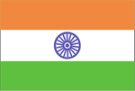 |
The National Flag is a horizontal tricolour of deep saffron (kesaria) at the top, white in the middle and dark green at the bottom in equal proportion. The ratio of width of the flag to its length is two to three. In the centre of the white band is a navy-blue wheel which represents the chakra. Its design is that of the wheel which appears on the abacus of the Sarnath Lion Capital of Ashoka. Its diameter approximates to the width of the white band and it has 24 spokes. The design of the National Flag was adopted by the Constituent Assembly of India on 22 July 1947.
(Source: National Portal of India at India.gov.in) |
National Symbol : Burung Garuda (Eagle)
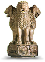 |
The state emblem is an adaptation from the Sarnath Lion Capital of Ashoka. In the original, there are four lions, standing back to back, mounted on an abacus with a frieze carrying sculptures in high relief of an elephant, a galloping horse, a bull and a lion separated by intervening wheels over a bell-shaped lotus. Carved out of a single block of polished sandstone, the Capital is crowned by the Wheel of the Law (Dharma Chakra) .
In the state emblem, adopted by the Government of India on 26 January 1950, only three lions are visible, the fourth being hidden from view. The wheel appears in relief in the centre of the abacus with a bull on right and a horse on left and the outlines of other wheels on extreme right and left. The bell-shaped lotus has been omitted. The words Satyameva Jayate from Mundaka Upanishad, meaning 'Truth Alone Triumphs', are inscribed below the abacus in Devanagari script. |
National Day :
- Republic Day: 26th January is celebrated as the Republic day in India. This commemorates the declaration of India as a Republic and coming into force of its constitution on 26th January 1950.
- Independence Day: 15th August is celebrated as Independence Day as India achieved independence from British Colonial rule on 15th August 1947.
History of India :
INDIA is one of the oldest civilizations in the world with a kaleidoscopic variety and rich cultural heritage. The oldest historical evidences date back to Neolithic Age when Mehrgarh and Kotdiji in North-Western part of India was habitated in nearly 7000BC. There are specific evidences of rice cultivation in those days. Similar evidences are also found in parts of Central India in Narmada valley which is believed to be inhabited in 9000 BC.
However, the most well known example is that of Indus Valley Civilization which flourished in 2600 to 1900 BC. It is well known for its town planning, trade and urbanization. This was followed by the so called Aryan invasion from the North West which led to the destruction of the old civilization and gave birth to the new civilization in the region of Ganga-Yamuna doab. It was called the Vedic Age. It coincided with the Iron Age. It flourished from 1500 to 500 BC.
The later part of the Vedic Age saw the establishment of the Mahajanapadas and the dawn of the Maurya Empire. This was followed by the Guptas, Gahadawalas, Parmaras in the north, Gaudas and Palas in the East, Rashtrakutas, Satavahanas in the West and Central part and the Cholas, Cheras and Pandyas in the South.
Around 700 AD, Muhammad Bin Kasim