Size
147,570 sq. km. or 56,977 sq. miles
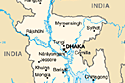
Geography
North-India : West Bengal and Meghalaya
West-India : West Bengal
East-India : Tripura& Assam and Myanmar
South : Bay of Bengal
Climate
Sub-tropical monsoon, Winter ( November-February) ,temperature :
average maximum 29°C, average minimum 11°C ; Summer (March-June),
temperature : average maximum 32 °C, average minimum 21 °C ; Monsoon
( July-Oct.)
Population
137 million ( estimate -2005)
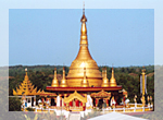
- by religion - Muslim (88.3%), Hindu (10.5%), Buddhist ( 0.6%), Christian ( 0.3%) and Animists and believers in tribal faiths ( 0.3%)
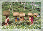
- by ethnicity – Predominantly mixed group of Proto Austroloids /Dravidians, Mongoloids and Aryans
Flag and meaning
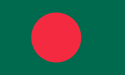
Green field with a large red disk shifted slightly to the hoist side of center; the red disk represents the rising sun and the sacrifice to achieve independence; the green field symbolizes the lush vegetation of Bangladesh.
National symbol
 National day
March 26, Independence and National Day
Language
National language: Bangle (95.5% speak Bangle and 0.5% other dialects). English is second most important language